Crustal Deformation Observed by Synthetic Aperture Radar (SAR)
Released:2007.10.02 Last update: 2007.10.08 JAPANESE
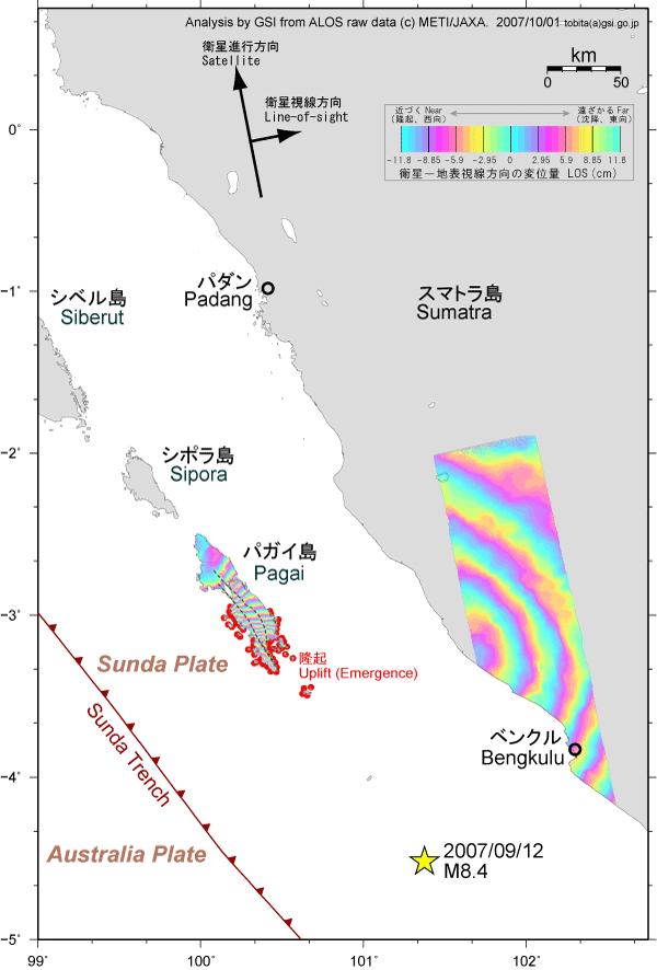
SUMARRY
- Coseismic displacements in Line-of-sight (LOS) direction were measured
as changes of range between ground suface and the satellite at the West
sky. The maximum displacement is about -2 m, which is displacement toword
the satellite.
- There are two discontinuities of phase in Pagai island (Pulau Pagai), as
shown in the broken lcurves. Some field survey team will probably find
surface rupture. The rupture should not be the earthquake source fault.
- Emergence due to uplift was observed in South Pagai island (Pulau Pagai
Selatan).
Crustal Deformation by InSAR
Coastal Change detected by SAR
Satellite and Sensor
PALSAR sensor onboard "Daichi" (ALOS) satellite launched by Japan Aerospace Exploration Agency on January 24, 2006
Suthern Sumatra Earthquake in 2007
| Date-time |
September 12, 2007 18:10 (Local time), 20:10 (JST), 11:10 (UTC) |
| Hypocenter location |
4.520°S, 101.374°E Depth:34 km |
| Magnitude |
8.4 (USGS) |