MENU
GSI, being the competent authority of the Survey Act, conducts national surveying and mapping activities, which provide a basis for the land management.
Historically it dates back to 1869 when cadastral Registration Map Section was established in the office of Geography Department, Ministry of Civil Service. Later in 1888 it was reorganized as Japanese Imperial Land Survey, and finally in 1945 it became the Geographical Survey Institute.
In April 2010, the official English appellation is changed to "Geospatial Information Authority of Japan."
The surveys GSI performs provide positional data (longitudes and latitudes) of the land and elevations from the mean sea level. A triangulation point and a benchmark give the exact position and elevation of that particular point on the earth, respectively. Today in addition to them GPS-based control stations are established for precise positional measurements where signals from the GPS satellites are continuously observed.
These control points are widely used for such purpose as public surveys executed by the national government and other public organs, for observations of crustal movements through continuous and repeated surveys, and for researches for disaster prevention including studies on earthquakes.
Preparation of various base maps, notably the topographical map series of 1/25,000 that cover the whole country, is another important task of GSI. Those maps are used as a basis for maps diverse public and private sectors prepare, such as administration area maps, road maps, GSI compiles several thematic maps (Land Use Map, Land Condition Map, Volcanic Land Condition Map, Map of Active Faults in Urban Area, etc.), which are an effective tool for disaster prevention efforts and national development. These maps are available in paper and in digital form (CD-ROM). Aerial photographs are also published.
Addressing the needs of the times we have introduced a new infrastructure concept, which we have been promoting as "Digital Japan" a virtual and real-time representation of the land realized by integrating various geospatial information and made accessible to anyone on the internet. As a sole responsible organ for national survey and mapping, we have been actively engaged in international cooperation in the field of survey and mapping and geosciences as well.
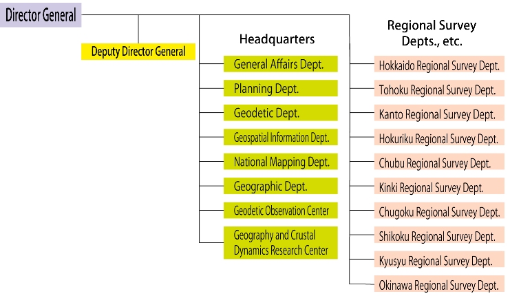
Main roles
|
Office in charge
|
|
National examination and registration of surveyors and assistant surveyors, approval of copy and use of survey results
|
General Affairs Department
|
General Affairs Division
|
|
Public relations and hearings, information service, consultations on survey and mapping, visitor information, management of Science Museum of Map and Survey
|
Public Relations Office
|
|
Management of surveying and mapping technology, standardization of geographic information
|
Planning Department
|
Technical Management Division
|
|
Administration of public survey
|
Survey Guidance Division
|
|
International cooperation, international research exchange, Global Mapping project (general affairs)
|
International Affairs Division
|
|
General management of geospatial information and GIS policy
|
Geospatial Information Planning Office
|
|
Disaster management efforts
|
Disaster Management Office
|
|
Geodetic activities including GPS survey, VLBI survey, leveling, gravity survey, and geomagnetic survey, management of control points
|
Geodetic Department
|
|
Reference service, publication and issuance of various survey data of control points, paper and digital maps, aerial photograph etc., GSI Web site, geospatial information service, clearinghouse management
|
Geospatial Information Department
|
|
Data providing and updating for the Digital Japan Basic Map (map information, ortho image and geographical names), including fundamental geospatial data, area data of municipalities, and R&D for the preparation of the geospatial information
|
National Mapping Department
|
|
Geographic studies of environmental monitoring, lakes and marshes, land use, land condition, active faults and volcanoes, Global Mapping project (techninal affairs), middle and small scale map compilation, disaster management geoinformation, 3D and digital map production
|
Geographic Department
|
|
GPS-based control points, crustal movement continuous monitoring, tidal observation
|
Geodetic Observation Center
|
|
Basic studies related with geography and crustal dynamics, Coordinating Committee for Earthquake Prediction, UNJR (United States-Japan Conference on Utilization of Natural Resources), Coastal Movements Data Center
|
Geography and Crustal Dynamics
Research Center
|
|
Works in each region (basic surveys, Survey Act enforcement, etc.)
|
Regional Survey Departments
|
Executives
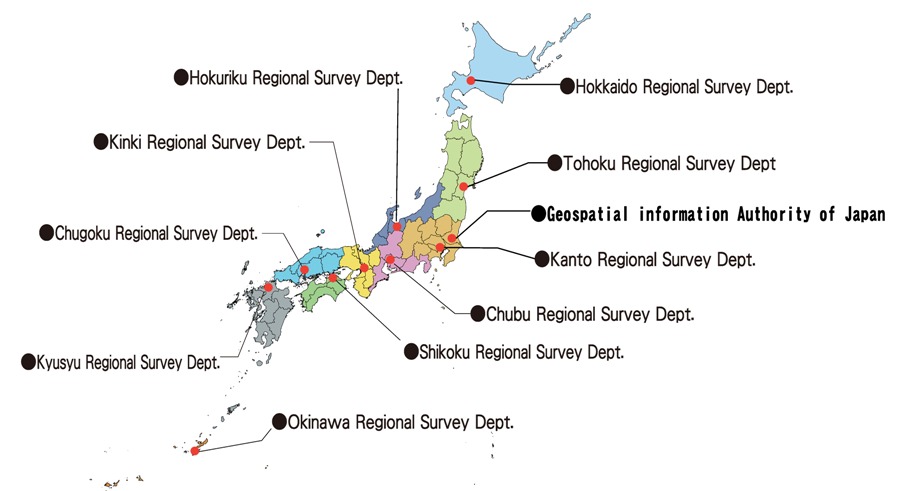
Location of GSI Head Office and Regional Offices
|
|
|
Geospatial Information Authority of Japan
|
TEL:+81-29-864-1111
1, Kitasato, Tsukuba 305-0811
|
|
|
|
Hokkaido Regional Survey Department
|
TEL:+81-11-709-2311
Sapporo Daiichi Government Building, 2-1-1, Kita Hachijo Nishi, Kita-ku, Sapporo 060-0808
|
|
|
|
Tohoku Regional Survey Department
|
TEL:+81-22-295-8611
Sendai Daisan Government Building, 1-3-15, Gorin, Miyagino-ku, Sendai 983-0842
|
|
|
| Kanto Regional Survey Department |
TEL:+81-3-5213-2051
Kudan Daini Government Building, 1-1-15, Kudanminami, Chiyoda-ku, Tokyo 102-0074
|
|
|
|
Hokuriku Regional Survey Department
|
TEL:+81-76-441-0888
Toyama Government Building, 11-7, Ushijima Shinmachi, Toyama 930-0856
|
|
|
| Chubu Regional Survey Department |
TEL:+81-52-961-5638
Nagoya Government Building No.2, 2-5-1, Sannomaru, Naka-ku, Nagoya 460-0001
|
|
|
| Kinki Regional Survey Department |
TEL:+81-6-6941-4507
Osaka Government Building No.4, 4-1-76, Otemae, Chuo-ku, Osaka 540-0008
|
|
|
|
Chugoku Regional Survey Department
|
TEL:+81-82-221-9743
Hiroshima Government Building, 6-30, Kamihatchobori, Naka-ku, Hiroshima 730-0012
|
|
|
|
Shikoku Regional Survey Department
|
TEL:+81-87-811-1900
Takamatsu Sunport Government Building, 3-33 Sunport, Takamatsu 760-0019
|
|
|
|
Kyushu Regional Survey Department
|
TEL:+81-92-411-7881
Fukuoka Government Building, 2-11-1, Hakataeki Higashi, Hakata-ku, Fukuoka 812-0013
|
|
|
|
Okinawa Regional Survey Department
|
TEL:+81-98-855-2595
Naha Daiichi Regional Government Building, 1-15-15, Hikawa, Naha 900-0022
|
|
|
How to get to GSI
English Brochures
Brief Overview of the GSI
|