Crustal movement information
|
Recent technologies for surveys and monitoring of crustal movement include GNSS CORSs (GNSS Continuously Operating Reference Stations), VLBI(Very Long Baseline Interferometry), leveling, strengthened control point survey, gravity survey, geomagnetic survey, tidal observation, SAR(Synthetic Aperture Radar) and such.
In emergency an expert team is immediately sent to the site for mobile observation. Real-time observation of crustal movements is made possible by GNSS CORSs, where radio waves from the satellites are constantly received. The observation data are sent real-time from those stations established throughout the country to GSI(Tsukuba, Ibaraki Prefecture) by a dedicated line. They underpin crustal movement analysis and monitoring efforts.
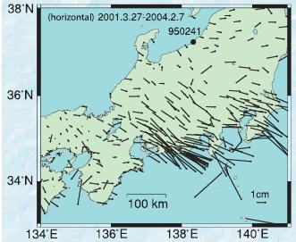
The diagram shows the data of horizontal displacement observed in the Tokai region due to crustal movements during the period of 27 March 2001 to 7 February 2004 with reference to the GNSS CORS in Oogata, Niigata Prefecture(950241). From the Tokai region to Nagoya an area of displacement in the south-east direction is identified. Recent data have indicated a notable decline in micro seismic activities in this area. This is a phenomenon observed for the first time in the area including the hypothetical epicenter of the possible Tokai Earthquake and its neighborhood. The data are regarded as a possible key to understanding a mechanism of the Tokai Earthquake.
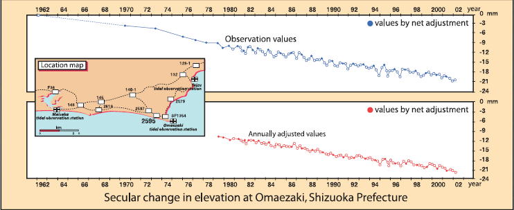
Secular change in elevation at Omaezaki, Shizuoka Prefecture This is a survey for precise measurement of the elevation of the benchmarks, approximately 17,700 points in total, established along the major national highways in Japan. Vertical displacement of the crust can be determined at a millimeter precision through analysis of the elevation data. The data show some seasonal changes repeated every year and a continuous subsidence of about 5mm per year. If the subsidence should stop or turn into an upheaval, it can be considered a precursor of an earthquake. 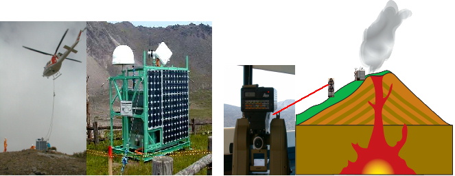
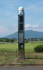
At a time of an earthquake or a volcanic eruption, or when the risks are high, GSI conducts mobile observation by densification of the observation network for a hazardous area for better understanding of crustal movement. The major components of mobile observation are GNSS continuous observation, distance-angle observation, and leveling, for determining horizontal and vertical displacement, while gravity and geomagnetism surveys contribute to identify internal physical changes of the earth. The mobile observation provides data of crustal movements of such locations where there are no permanent observation points established. The data can be very valuable in developing disaster prevention measures. The photo shows an unmanned GNSS receiver(left), distance-angle measurement equipment(right). They rely on solar energy and wind for power and on satellites cellular phone for telecommunication. This new technology provides terrain structural information by taking advantage of the long-range propagation characteristics of radar signals emitted from the satellites. It enables a terrain observation unaffected by smoke or clouds(left), while crustal movement can be measured in terms of area using an interferogram(right) formed from the radar images acquired before and after an earthquake.
For more detail |