Geodetic survey
|
GSI Activities
International Committee
 |
GSI has established and maintained approximately 130,000 national control points of various kinds throughout the country, which are triangulation points for precise positional data (longitude and latitude), benchmarks (elevation) and such. They play an important role in the national surveying activities as the source of the base data.
The standard geodetic datum of Japan was shifted from the old Japan Geodetic System, which had been used for many years, to the global geodetic reference system; "Japanese Geodetic Datum 2000 (JGD2000)" usable in the world in April 2002.
Japanese Geodetic Datum 2011 (JGD2011)In October 2011, GSI released "Japanese Geodetic Datum 2011 (JGD2011)" as the new standard datum of Japan because of the wide area crustal deformation caused by "The 2011 off the Pacific coast of Tohoku Earthquake" which occurred on March 11, 2011.
The parameter file and the software for transforming coordinates from JGD2000 to JGD2011 are available from our Public Survey page (in Japanese).
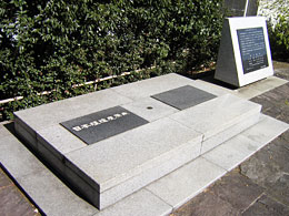
Japanese origin of longitude and latitude Longitude and latitude are means to express an exact positions on the globe. This is the very origin of all the surveys conducted in Japan . Longitude: 139° 44' 28.8869" (East) Latitude: 35° 39' 29.1572" (North)
Japanese datum of leveling Elevations of Japan are determined with reference to the mean sea level of Tokyo Bay (elevation 0 m). The reading of 0 on the crystal scale embedded in the stone base monument of the datum indicates 24.3900m above the mean sea level of Tokyo Bay .
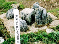
Triangulation point
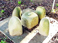
Benchmark
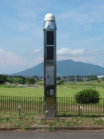
GNSS Earth Observation Network System (GEONET)GSI has established more than 1,300 GNSS Continuously Operating Reference Stations (GNSS CORSs) throughout the country. Movement of the land of Japan is daily monitored by GNSS Earth Observation Network System (GEONET). Observation data thus obtained are made available for actual survey works and for studies of earthquakes and volcanic activities.
GNSS CORS For more detail
|