

Experimental release of Japan map in multilingual notation
Experimental release of Japan map in multilingual notationEasy-to-understand maps for overseas visitorsGSI has been working on making the easy-to-understand maps for overseas visitors by settling "Notation Rules of Geographical Names, etc. in English" and new map symbols for overseas visitors (hereinafter referred to as “the rules”), to support providing overseas visitors with trouble-free trip and safe and comfort stay in Japan.
Japan map in multilingual notationThis time, GSI has released an online map in multilingual notation adopting above mentioned rules on an experimental basis in order to expand use of the rules and find issues for improvement of the maps for overseas visitors. The map has released in English, French, Korean, (both traditional and simplified) Chinese, and Romanized Japanese. Employing vector tile format (in Japanese),the map provides foreign visitors with easy-to-understand information by displaying annotations and symbols in each language, and also by reading geographical name with its correct pronunciation in Japanese through a web browser. Users are required to comply with the “GSI Website Terms of Use” to use these vector tiles that adopt the rules. GSI hopes that the purpose of this experimental release is well understood and that many people use the map. Click each language to display it in that language. Users enable to switch a language on the map by clicking "Language" at the top left corner of the screen. English, French, Korean, Simplified Chinese, Traditional Chinese, and Romanized Japanese Display example: Map in English notation 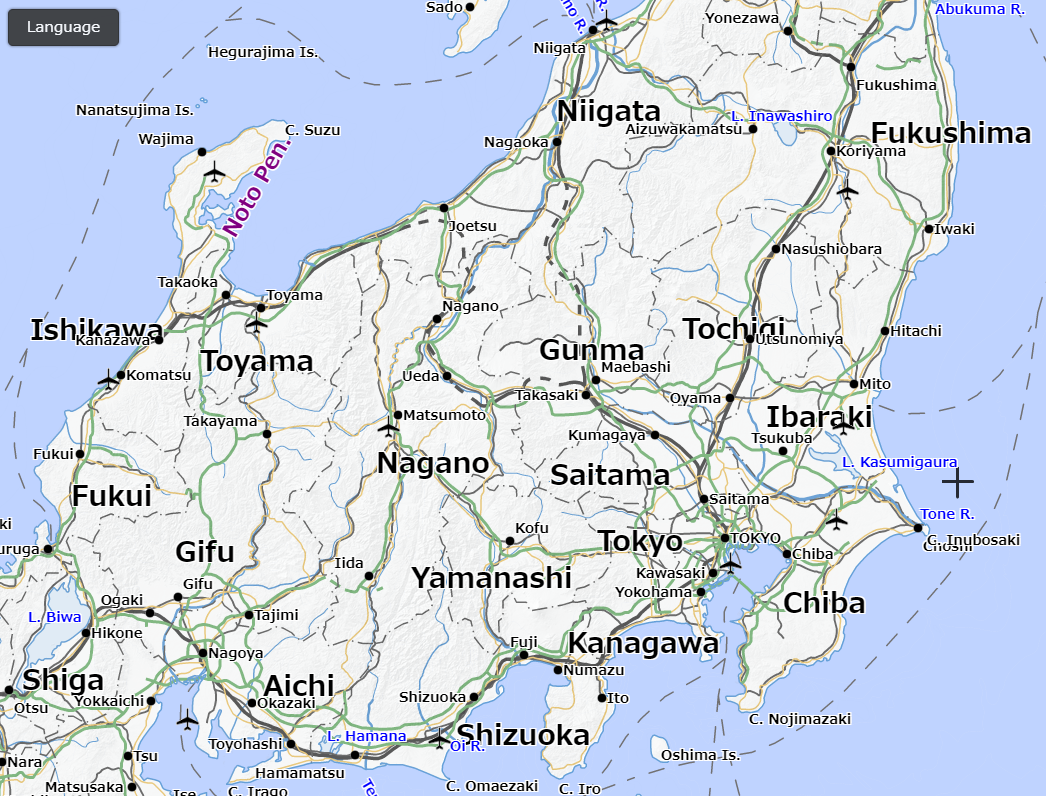 Rules of notation in EnglishTranslation of Japanese notation into English according to Notation Rules of Geographical Names, etc. in English. (in Japanese)
Of the Japanese notation on GSI Maps, geographical names of natural features, residential geographical names, and traffic facilities names are mainly translated. Rules of notation in Non-English languagesOf the Japanese notation on GSI Maps, geographical names of natural features, residential geographical names, and traffic facilities names are mainly translated. Translation is automatically converted from English or Japanese.
1. French is automatically converted based on conversion rule from English. Conversion rule for French (PDF: 166KB in Japanese) 2. Korean is automatically converted based on conversion rule from Japanese. Conversion rule for Korean (PDF: 277KB in Japanese) 3. Simplified Chinese is automatically converted based on conversion rule from Japanese kanji (Chinese character). Conversion rule for Simplified Chinese (PDF: 303KB in Japanese) 4. Traditional Chinese is automatically converted based on conversion rule from Japanese kanji (Chinese character). Conversion rule for Traditional Chinese (PDF: 304KB in Japanese) 5. Romanized Japanese Transportation facilities are converted based on conversion rule from English, and geographical names of natural features, residential geographical names are converted from Japanese. Conversion rule for Romanized Japanese (PDF: 108KB in Japanese) Displayed map symbolsMap symbols used in this map (see appendix) consist of the symbols used in GSI Maps and the symbols developed for overseas visitors.
Functions of the online map1. A voice-reading function and displaying information
By clicking map symbol on the map, a type of symbol and its name, if it has, will be displayed, and clicking the geographical name, the geographical name and its supplementary information will be displayed. Moreover, users could hear the correct Japanese pronunciation of geographical names through a web browser voice-reading function. Please note this function may not be usable at your browser. (Microsoft Edge, Google Chrome, Safari are confirmed operation.) Example (in English) 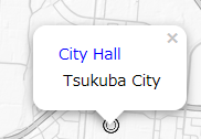 Type of symbol and its facility name 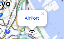 Type of symbol 2. Switching a language / displaying legends Users enable to switch a language on the map by clicking "Language" button. Users enable to display the legend link for each language by clicking "i" button next to respective languages. 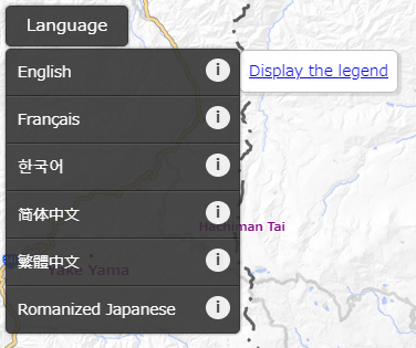 CautionsThe purposes of this experimental release of multilingual notation maps are improving the convenience of foreign visitors to Japan and understanding technical issues for providing multilingual notation maps.
* This “Japan map in multilingual notation” is the extension of Japan map in English notation, which we notified on May 16, 2019 at our English website.
|