

GSI started effort to include the location of ”Natural Disaster Monument”, which shows lessons from historical disasters experienced by our ancestors, on GSI Maps.
GSI will make efforts for popularization and dissemination of lessons from the disasters by including map symbol of “Natural Disaster Monument” on GSI Maps.GSI started effort to include the location of ”Natural Disaster Monument”, which shows lessons from historical disasters experienced by our ancestors, on GSI Maps.GSI started providing information about “Natural Disaster Monument*” via its web map, “GSI Maps”, on June 19, 2019. Through this effort, GSI hopes all local residents to understand reality of natural disasters that easily occur in respective regions, and moreover GSI will contribute to support enhancing their disaster preparedness.
*Natural Disaster Monument is a monument for future remembrance of natural disasters. It records the fact of natural disasters such as earthquakes, tsunamis, volcanic eruptions, floods and landslides to convey the lessons to the future generation. - As announced on March 15, 2019, GSI started to collect information on natural disaster monuments in 2019 in cooperation with local governments, and Regional Development Bureau of MLIT (Ministry of Land, Infrastructure, Transport and Tourism), and is now proceeding with the preparation for its release with approximately 200 municipalities. - Because 158 monuments in 48 municipalities are ready this time, GSI started providing the information through “GSI Maps” on June 19, 2019. - Other monuments in approximately 150 municipalities will be released on the web map as soon as they are ready. GSI will continuously request local governments to provide information, and regularly update and release information. - Furthermore, through this effort, GSI hopes all local residents to understand reality of natural disasters that easily occur in respective regions. This is because GSI would like to achieve disaster risk reduction by helping the people to appropriately respond to disasters in the light of the lessons learned from past disasters reminded by natural disaster monuments. Information on each natural disaster monument can be used as disaster prevention education at school for leaning local disaster histories, and so on. Press Release in Japanese 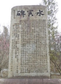
Natural disaster monument Display image of GSI Maps Display image of GSI Maps
(flood disaster: Saka town, Hiroshima Prefecture)
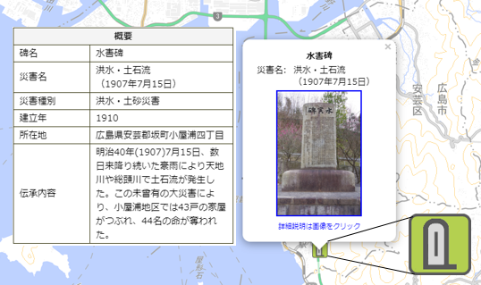 Display image of GSI Maps Please check the website below for detail information of natural disaster monument (Japanese only). |