

The 2011 off the Pacific coast of Tohoku Earthquake: Coseismic Slip Distribution Model
Crustal Deformation and Fault Model obtained from GEONET data analysisReleased: Apr. 21, 2011, Revised: Apr. 22, 2011, Japanese version of this page
Crustal Deformation and Fault ModelWe constructed a distributed slip model using coseismic surface displacement data observed by the GPS Earth Observation Network System (GEONET) for the 2011 off the Pacific coast of Tohoku Earthquake. The vertical displacement calculated using our slip model suggests that large subsidence occurs along the Pacific coast.
GSI manually collected GPS data which were unavailable due to the suspension of a data transmission system just after the earthquake. We used these data to revise the preliminary model presented on March 14, 2011. Slip Distribution Model and Predicted Vertical DisplacementCoseismic slip distribution
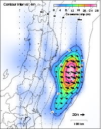 [PDF: 119KB] [PDF: 119KB]Fitting between observation and calculation 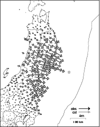 [PDF: 106KB] [PDF: 106KB] 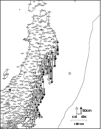 [PDF: 118KB] [PDF: 118KB]Vertical displacement calculated from our slip distribution model 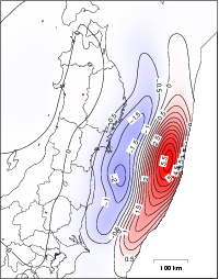 [PDF: 104KB] [PDF: 104KB]The 2011 off the Pacific coast of Tohoku Earthquake
Copyrights and CreditsCopyright (C) Geospatial Information Authority of Japan, All rights Reserved.
We welcome links from your website to this website. When using materials on this website, we ask that proper credit be given. ContactIMAKIIRE Tetsuro : Research Coordinator for Geography and Crustal Dynamics Research
TOBITA Mikio : Head of Division (Crustal Deformation Research Division) OZAWA Shinzaburo : Chief Researcher (Crustal Deformation Research Division) NISHIMURA Takuya : Chief Researcher (Crustal Deformation Research Division) SUITO Hisashi : Researcher (Crustal Deformation Research Division) KOBAYASHI Tomokazu : Researcher (Crustal Deformation Research Division)   Some files are available in PDF format. To view PDF files, Adobe System's free "Adobe Reader" software must be installed. Please visit the following link to download the free software. |