

The Niigata-Kobe Tectonic Zone
The Exhibition of IUGG2003The GEONET clarified the contemporary deformation of the Japanese Islands. One of the most interesting features is the high-strain rate band crossing central Japan from Niigata to Kobe. Tada, Sagiya and Miyazaki [Tada et al., 1997; Sagiya et al., 2000] proposed to call this zone as the Niigata-Kobe Tectonic Zone(NKTZ).
The Japanese Islands belongs to four tectonic plates, that is, the Okhotsk(or North America), the Eurasia(or Amurian), the Pacific, and the Philippine Sea plates (Figure 1). The former two continental plates are colliding in Honshu, the largest island of Japan. The location of the boundary of these plates is still controvertible. Before starting of the continuous GPS observation, most researchers considered that the boundary is the Itoigawa-Shizuoka Tectonic Line(ISTL). However, the deformation revealed by the GEONET suggest that WNW-ESE contraction is localized in the zone from Niigata to Kobe(NKTZ) and that there are no large strain-rate around ISTL except its northern part. Figure 2 shows principle strain rate estimated from GPS displacements from January 1998 to January 2000. The zone where WNW-ESE strain is high extends from Niigata to north along the coast of Sea of Japan. Distribution of dilatation and maximum shear strain shown in Figures 3 and 4 clearly indicate the strain localization crossing central Japan. Therefore, NKTZ is a part of plate boundary between the Okhotsk and Eurasian plates. One important characteristic of the NKTZ is that the high-strain zone is relatively wide, say, ~100km wide, not a sharp plate boundary. Many large earthquakes including the 1995 M7.2 Kobe earthquake occurred in the NKTZ. High strain rate corresponding NKTZ can be identified in the strain rate by triangulation and trilateraltion surveys for ~100 years. These observations support that the high-strain rate in the NKTZ reflect on the long-term tectonics of Japan and that the NKTZ is the plate boundary between the Okhotsk and Eurasian plates. 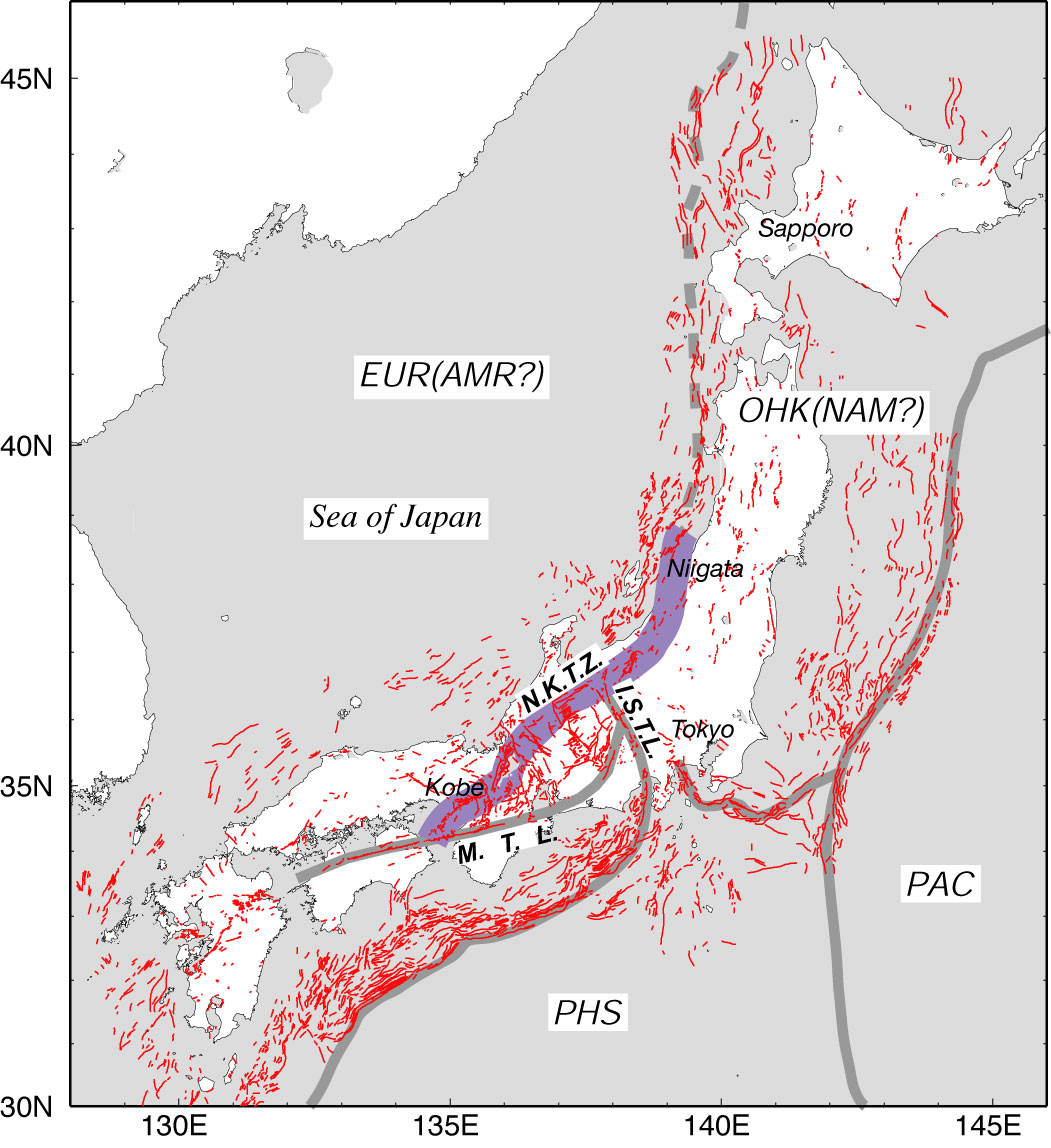
Figure 1. Tectonic map of Japan. Thin black lines denote active faults. Gray lines denote plate boundaries and major tectonic lines. Dashed gray line denotes a possible plate boundary between the Eurasian(or Amurian) and the Okhotsk(or North American) plates. Thick gray line indicates location of the Niigata-Kobe Tectonic Zone (NKTZ). PAC: Pacific plate, PHS; Philippine Sea plate, EUR: Eurasian plate, AMR; Amurian plate, OHK: Okhotsk plate, NAM: North American plate, ISTL: Itoigawa-Shizuoka Tectonic Line, MTL: Median Tectonic Line.
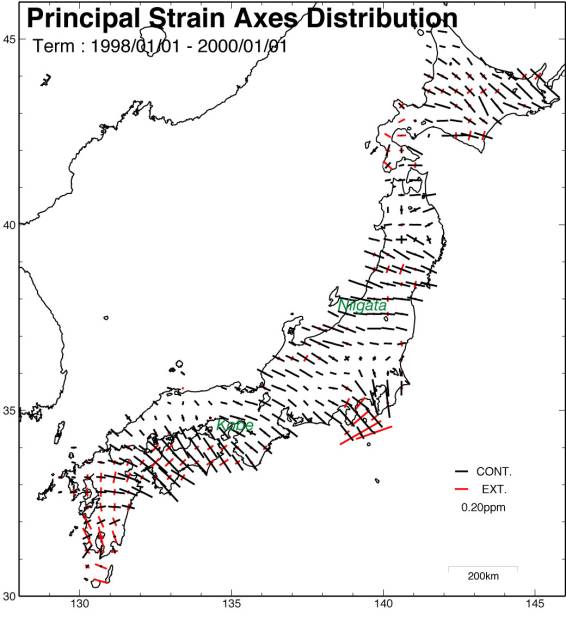
Figure 2. Principal strain axes estimated from GPS displacement for two years. 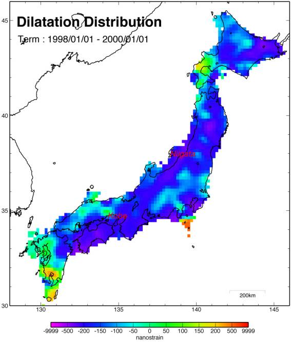
Figure 3. Dilatation strain estimated from GPS displacements for two years. 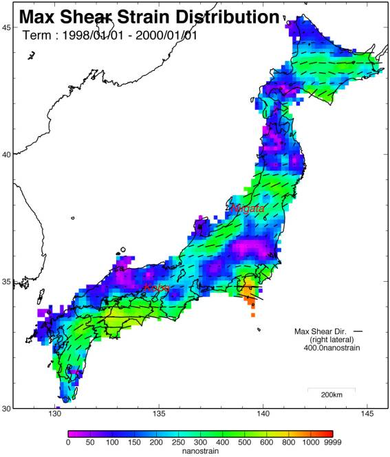
Figure 4. Maximum shear strain estimated from GPS displacements for two years. Reference
|