

Boso Silent Earthquake
The Exhibition of IUGG2003AbstractAnalysis of Global Positioning System (GPS) data shows transient crustal deformation in the Boso peninsula, central Japan, for about fifty days from October 2002. The southeastward horizontal displacements detected suggest the occurrence of aseismic slip on the plate boundary between thePhilippine Sea plate and the North American plate, six years after a similar event in 1996. We estimate an area of aseismic slip with moment magnitude (Mw) 6.6 centered off the Boso peninsula, adjacent to associated seismic activity. Slip evolution of the 2002 aeismic slip started from ~October 4 and migrated from north to south for about 14 days, followed by temporary subsidence and restarting of slip which lasted until ~December 2, propagating more southward. Similarities in focal area and slip process between the 1996 event (Mw=6.5) and the 2002 aseismic slip suggest the Boso aseismic slips as characteristic silent earthquakes together with the repetitive occurrence of seismic swarm in a similar region every six to seven years. A more tightly coupled southern area that did not release enough energy in the 1996 event may have caused the differences in magnitude, central slip area, and duration between the 1996 and the 2002 events, if the hypothesized six to seven years recurrence interval is true, based on swarm seismicity.
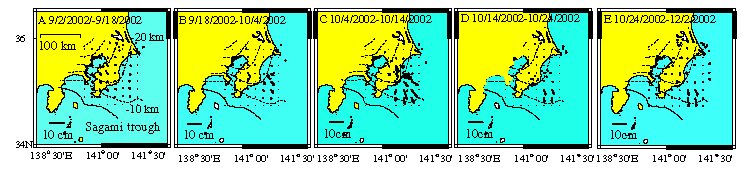
Figure. Time evolution of the estimated aseismic slip on the plate boundary. Dashed lines represent itho-depth contours of the plate boundary between thePhilippine Sea plate and the North American plate [Ishida, 1992]. Solid arrows represent slip of the North American plate against the Philippine Sea plate. Open circles represent hypocenter with depth<=50km and Mw>=2 determined by JMA. (A) September 2 - September 18 20022 (B) September 18 - October 4 2002 (C) October 4 -October 14 2002 (D) October 14 - October 24 (E) October 24-December 2 2002.
IntroductionThe Philippine Sea plate is subducting beneath the Boso peninsula, central Japan, with the Pacific plate underlying the Philippine Sea plate (1) (see Fig. 1). Because of the complicated tectonic setting, shown in Fig. 1, seismic events are numerous off the coast of the Boso peninsula (2). Permanent GPS observation sites set up by the Geographical Survey Institute ofJapan (GSI) have been in operation since 1994. Fig. 2A shows steady northwestward crustal deformation on the Boso peninsula, revealed by these GPS sites. Based on the crustal deformation rate in Fig. 2A, the coupling rate off the east coast of the Boso peninsula is estimated at between 1 and 2 cm/year with the southern part showing a higher coupling rate between the Philippine Sea plate and the overriding North American plate (3). Under this tectonic setting, ground motion deviating from the steady northwestward deformation in Fig. 2A occurred in 1996. Fig. 2B shows the detected transient crustal deformation at GPS stations relative to the Ohgata station, Fig. 1, for the period between April 8 and June 10, 1996 (Japan Time). As shown in this figure, the southeastward ground displacements are observed, in contrast with Fig. 2A. From this crustal deformation, aseismic slip was estimated off the east coast of the Boso peninsula with its rupture propagating to the south with a time duration of about 7 days (3, 4). Six years after the 1996 event, quite similar abnormal crustal movements started from around October 4 2002, indicating the occurrence of another interplate aseismic slip in this region. Employing a Kalman filter, we estimated the time evolution of the 2002 Boso aseismic slip and compared the 2002 event with the 1996 silent earthquake in order to investigate the nature of silent earthquakes.
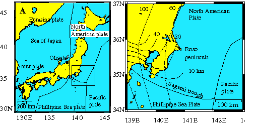
Figure 1. Tectonic map in and around the Boso peninsula, central Japan 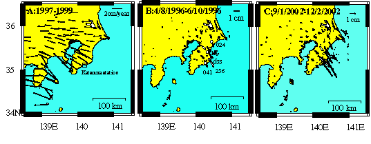
Figure 2. (A) Velocity field in the Boso peninsula, estimated over the period between 1997 and 1999.
(B) Solid arrows represent ground displacements at GPS stations from April 8 toJune 10 1996 (Japan Time).White arrows indicate computed ground displacements from the estimated model. Open circles represent GPS sites whose time series data are shown in Figure 3. Small open circles represent hypocenter with depth<=50 km and Mw>=2 in May 1996 determined by the Japan Meteorological Agency (JMA). Data are from JMA. (C) Solid arrows show ground displacements at GPS stations from September 1 toDecember 2, 2002.White arrows indicate computed ground displacements at GPS site used in Kalman filtering analysis. Small open circles represent hypocenter with depth<=50 km and Mw>=2 in October 2002 determined tentatively by JMA. Data are from JMA. 2002 Transient Crustal DeformationFig. 2C shows the 2002 transient ground motion which is quite similar to that of the 1996 event in Fig. 2B. However, there are two notable differences between Figs. 2B and 2C. Firstly, the overall magnitude of the 2002 event is 40-100 % larger than that of the 1996 one. Secondly, the center of the crustal deformation area shifted southward because of a large horizontal displacement at the 041 GPS site in 2002, which was about three times larger than that in 1996. Associated with these anomalous crustal movements, a seismic swarm occurred off the coast of the Boso peninsula (5)(see Figs. 2 and 4). These earthquakes are regarded as activities on the upper surface of the Philippine Sea plate with a focal depth of between 20 and 30 km (5). Uncertainties of hypocenter are about 1 km for horizontal coordinates and 1 km for focal depth. Fig. 3 shows the time series data of ground displacements at selected stations from Fig. 2B. As shown, a step-like event was observed between October 4 and 14, followed by gradual subsidence at the 024 and 033 sites. Compared with the 024 and 033 sites, stations 226 and 041 further south on the Boso Peninsula show another start of crustal deformation which lasted about 20 days from ~October 24. The shape of the rise time and initiation time seem to differ from station to station. Considering the similarity between the 1996 and 2002 transient crustal deformation and associated seismic swarm in Fig. 2, it is most likely that the 2002 anomalous crustal deformation was caused by another silent earthquake between the subducting Philippine Sea plate and the overriding North American plate.
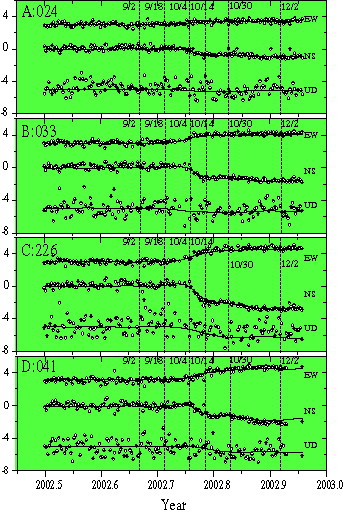
Figure 3. Detrended time series of ground displacements at selected GPS sites in the Boso peninsula AnalysisOn the assumption that aseismic slip is causing the abnormal crustal deformation in the Boso peninsula, we estimate the slip history between the Philippine Sea plate and the overriding plate, applying the Kalman filter, (6-9), following the time dependent inversion technique, (10, 11) to the data in Figs. 2 and 3. We used east-west and north-south, and up-down displacement data at 28 selected GPS sites (Fig. 2C) on the Boso peninsula. As a model region, we use the plate boundary estimated by Ishida [1992](1). Adopting these model regions represented by spline surfaces (6), we estimated the slip history between September 1, 2002 and December 16, 2002. We set slip components at zero at the edge of the fault patch as a boundary condition, considering that this region corresponds to the edge of the Philippine Sea plate. Furthermore, we restrict the direction of the slip to be southward and eastward not to be against the direction of the plate convergence of this region. Smoothing priors in time and space are estimated by maximizing the log likelihood of the system.
ResultsOur analysis for the 2002 Boso aseismic slip gives an area of slip off the east coast of the Boso peninsula (Fig. 4). Figs. 4A-4E show the estimated time evolution of the 2002 aseismic slip in the Boso peninsula with 1 standard deviation estimated at about 2 mm. An aseismic slip area appears off the east coast of the Boso peninsula until October 4. After October 4, the slip rate increases and the slip area expands southward before gradually subsiding until the end of October. After October 24, another stage of crustal deformation started lasting for about 20 days with its center shifted more southward (Fig. 4E). A seismic swarm appears in the vicinity of the estimated slip area as shown in Fig. 4. This difference in location between the seismic activity and aseismic slip area indicates that the stress buildup in the neighboring area is the cause of a seismic swarm. Southward migration of the central slip area in our model is consistent with a gradual increase of earthquakes in the southern part of the Boso peninsula over time, as shown in Figs. 4A-4C. The computed ground displacements (Figs. 2 and 3) from the estimated slip model are consistent with the observed displacements. We also estimated a total slip area for the 1996 event, to compare it with the 2002 silent earthquake under the same condition of analysis, though the detailed modeling for the 1996 asesimic slip is conducted by Sagiya and Inoue (4) and Sagiya (3). Compared with the 1996 event, the center of the 2002 aseismic slip is shifted southward with an estimated moment larger by about 70% (Fig. 5). This difference reflects the spatial pattern of the observed abnormal crustal motion in Fig. 2C, in which GPS sites especially in the southern part of the Boso peninsula shows a larger motion than that of the 1996 event. Sagiya and Inoue (4) and Sagiya (3) estimated space-time slip distribution of the 1996 event by estimating all slip parameters in an inversion with smoothness of slip distribution incorporated in space-time dimension. They used daily coordinates at 30 GPS sites and assumed the plate configuration by Ishida (1). Their detailed analysis shows that the aseismic slip of the 1996 event propagated from north to south, as was observed for the 2002 event. Their resolved slip area overlaps almost the same area in Fig. 5A with a seismic moment totaling Mw6.4 for a period of seven days. We think that a difference in estimated moment magnitude of the 1996 event between Sagia (3) and this study is within the uncertainty of models and our approximate model agrees well with their detailed model in basic points. Overlapping of the slip areas and similar rupture process between the 1996 and 2002 Boso aseismic slips suggest that these events share characteristic features, as is often reported for characteristic radiative earthquakes in many areas (e.g. 12). In addition to the similarities between the 1996 and the 2002 events, repeated swarm seismicity is reported by the National Research Institute for Earth Science and Disaster Prevention of Japan (5). Fig. 6 shows seismic activity from 1970 in a rectangular area in Fig. 5 with hypocenter data from the Japan Meteorological Agency (JMA) with focal depth <= 50km. As shown in this figure, high seismicity occurred in June 1977, May 1983, December 1990-January 1991 before the 1996 aseismic event in which hypocentral depth ranges mostly from 20 to 30 km, presumably on the upper surface of the Philippine Sea plate. High seismicity in 1987 reflects aftershocks of the 1987 Chiba-Toho-Oki earthquake which occurred in the subducting Pacific plate. Seismic activity in 2000 is probably affected by the 2000 Izu Islands volcano-seismological event which caused northeastward crustal deformation of between 1 and 2 cm in this region. NIED (5) reported southeastward uplift changes in the tiltmeter at Katuuura station, shown in Fig. 5, associated with the 1983, 1996, and 2002 events. As for the 1990-1991 swarm seismicity, a small similar change in the tiltmeter in Katsuura is recorded, though it is within the limit of detection (5). Considering a similar tilting change from the 1983 swarm seismicity, it is likely that a similar aseismic event occurred in May 1983. Though geodetic signals are less clear for 1990-1991 and there is no anomalous observation for the 1977 seismic activity, we hypothesize that aseismc slips off the Boso peninsula seem to be characteristic events and have an interval of about 6 to 7 years, as is proposed by NIED (5). Considering a coupling rate of about 1-2 cm/year in this region (3), it seems that most accumulated strain energy in this region is released by aseismic interplate slip, if this characteristic earthquake theory holds.
Figure 4. Time evolution of the estimated aseismic slip on the plate boundary.Dashed lines represent itho-depth contours of the plate boundary between thePhilippine Sea plate and the North American plate [Ishida, 1992]. Solid arrows represent slip of the North American plate against thePhilippine Sea plate. Open circles represent hypocenter with depth<=50km and Mw>=2 determined by JMA. (A) September 2 - September 18 20022 (B) September 18 - October 4 2002 (C) October 4 -October 14 2002 (D) October 14 - October 24 (E) October 24 -December 2 2002.
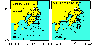
Figure 5. Estimated slip distribution on the plate boundary.
Nomenclatures are the same as those in Figure 4. (A) 1996 aseismic slip from April 15 toJune 1 1996 (B) 2002 aseismic slip from September 18 and December 2. Open square shows the location of the Katsuura station of the NIED.
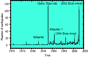
Figure 6. Number of earthquakes in a rectangular area in Figure 5A.1987 Chiba-Toho-Oki earthquake occurred within the subducting Pacific plate, followed by numerous aftershocks. Tiltmeter at Katsuura station of the NIED in Figure 5 detected a change from the seismic swarm in 1986, 1996, and 2002 [NIED 2002]. A slight change in tiltmeter in the 1990-1991 seismic swarm is also reported. Seismic activity in 2000 may be affected by the 2000 Izu islands seismo-volocanic activity.
References
|