Outline of Planning and Management of National Mapping and Surveying
BACKGROUND
Base maps and other geospatial information are essential and fundamental infrastructure for everyone from policy makers to hikers, from national project designing to everyday life, and they are often regard as a part of National Spatial Data Infrastructure (NSDI). Therefore, upgrading and improving the national base maps is urgent matter for every developing country. In addition, National Geospatial Information Authorities (NGIAs) are expected to respond to the dramatic progress of surveying and mapping technologies including satellite positioning and ICT applications. However, NGIAs are facing difficulties to undertake this responsibility and to implement their own tasks. Though this situation is often attributed to the lack of funding, the situation could be fairly improved by good planning and management.
COURSE OBJECTIVE
Policy of business improvement on development, provision, and promotion of geospatial information in NGIA shall be established.
Participants are expected to achieve the following outputs;
- Japan's surveying and mapping policies and legal framework are well understood and the shape of surveying and mapping policies of the participant's country are considered.
- Surveying and mapping theory and practical operation for a base of geospatial information development are well understood.
- Applications of geospatial information and trend of state-of-the-art technologies are understood, and utilization of domestic geospatial information is marshaled.
- Planning method conducive to the improvement of public surveying and mapping administration in the participant’s own country is acquired.
- Specific consideration is made aiming for the utilization of the acquired policies and technologies in the public surveying and mapping administration in the participant’s own country.
NUMBER OF PARTICIPANTS
About twelve (12)
QUALIFICATIONS
- Current Duties: Technical official in management levels (section head or deputy section head) in NGIA or be engaged in equivalent work, but subject on cadastral survey is not included as the main component of this course.
- Experience in the relevant field: Have more than 7 years-experience
- Educational Background: University graduate or equivalent
- Basic knowledge on mathematics
- Basic skill on computer operation method
- Language skill: Have a competent command of spoken and written English which is equal to TOEFL iBT61 or its equivalent. (This program includes active participation in discussions and development of the action plan, thus requires high competence of English ability both in conversation and composition. Please attach an official certificate for English ability such as TOEFL CBT, PBT, TOEIC IELTS etc, if possible)
- Health: must be in good health, both physically and mentally, to participate in the Program in Japan. Pregnant applicants are not recommended to apply due to the potential risk of health and life issues of mother and fetus.
There has been increased number of participants who suffer from chronic illness such as uncontrolled hypertension and uncontrolled diabetes during their stay in Japan. Stress connected with living in a foreign country might be a factor that worsens participants’ health status and it can result in failure to complete courses. Therefore to avoid such health risks, applicants are requested to enlist all medial conditions that may require treatment while they are in Japan.
- Age: be between the ages of twenty-nine and forty-five years.
- Gender Consideration: JICA is promoting Gender equality. Women are encouraged to apply for the program
TRAINING TERM
This training will be performed for four months from late August to late December.
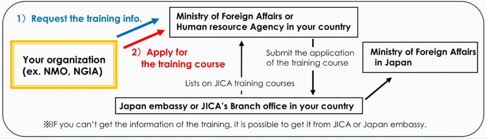
HOW TO APPLY
Please make contact with JICA's Branch office or government that is in charge of Training affairs for government officials.
Reference link
JICA training program
(Contact Us)
International Affairs Div. Planning Dept. GSI Japan
Kitasato1.Tsukuba-shi.ibaraki 305-0811
E-mail :