

Global Map Global version
|
Global Map Global Version is raster data which cover the globe in a single dataset and have three layers: Elevation; Land Cover; and Vegetation.
For details, please refer to "Global Map Data Archives (external link)". You can download Global Version data below. Elevation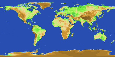
Elevation is elevation data at 1m interval covering the whole world.
Data of two periods, i.e., Version 1 and Version 2, have been developed and provided. Acknowledgement of written sources is necessary. Please show a text, "Geospatial Information Authority of Japan.", on your products. For details of Elevation data, please refer to "Elevation - Global version (external link)". Download Elevation data
Land Cover (GLCNMO)
The Global Land Cover by National Mapping Organizations (GLCNMO) is geospatial information in raster format which classifies the status of land cover of the whole globe into 20 categories. The classification is based on LCCS developed by FAO. Therefore, it is possible to compare and integrate GLCNMO and other land cover data products based on LCCS.
Acknowledgement of written sources is necessary. Please show a text, "Geospatial Information Authority of Japan, Chiba University and collaborating organizations.", on your products. For details of GLCNMO data, please refer to "Land Cover (GLCNMO) - Global version (external link)". Download GLCNMO dataVegetation (Percent Tree Cover)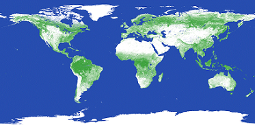
Vegetation (Percent Tree Cover: PTC) represents the density of trees on the ground. The data show the ratio of the area covered with branches and leaves of trees (tree canopy) to the ground surface seen from the above (vertical direction). Satellite images of the whole globe from the MODIS sensor of Terra were used for the data creation. As for deciduous trees, which drop all their leaves during the period of low temperature or dryness, the ratio of the most flourishing period of a year (Maximum Percent Tree Cover) was referenced as the Percent Tree Cover. PTC were developed by the secretariat of ISCGM in collaboration with GSI and Chiba University.
Acknowledgement of written sources is necessary. Please show a text, "Geospatial Information Authority of Japan, Chiba University and collaborating organizations.", on your products. For details of PTC data, please refer to "Vegetation (Percent Tree Cover) - Global version (external link)". |