Pixel Offset method
A pixel offset is a technique for measuring ground displacement, using a precise coregistraion between two SAR images. In this technique, a residual local offset after coregistration is regarded as an actual surface displacement.
The figure shows SAR images acquired before and after an earthquake. In general, the satellite positions and its flight directions are different between the two observations,thus two SAR images do not match completely. This is why corresponding pixels (same ground target) between the two images have a spatial shift one another. Applying an image matching with an accuracy less than 1 pixel, the positional displacement can be corrected, but there still remains the offset if there would be locally-distributed deformation. In the pixel offset method, a local residual offset indicated by a character of “K”, which is still remained even after a coregistraion between two images, is regarded as an actual ground surface displacement.
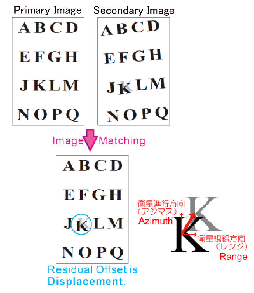
Illustration of pixel offset analysis(after Tobita et al., 2001)
Advantage
- Two displacement components are measurable: One is a displacement between the satellite and the ground target (RANGE component), the other one is a displacement in the satellite flight direction (AZIMUTH component).
- Large ground displacement is measurable: Suitable for crustal deformation observation for a large inland earthquake.
(NOTE: A standard InSAR analysis can measure only a range component, and in principle cannot measure large displacement of high spatial gradients)
Disadvantage
- Low measurement accuracy : several ten centimeters
- Low spatial resolution: several hundred meters to 1 kilometer
(NOTE: For an InSAR, the standard measurement accuracy is approximately a few centimeters, and the standard spatial resolution is approximately several ten meters.)
References
- T. Kobayashi, M. Tobita,and M. Murakami, Pixel offset technique for measuring local large ground surface displacement, Jour. Geodetic Society, Japan, 57, 71-81, 2011. (in Japanese with English abstract)
- T. Kobayashi, Y. Takada, M. Furuya, M. Murakami, Locations and types of ruptures involved in the 2008 Sichuan Earthquake inferred from SAR image matching, Geophys. Res. Lett. 36, L07302, doi:10.1029/2008GL036907, 2009.
- S. Fujiwara, M. Tobita, H. P. Sato, S. Ozawa, H. Une, M. Korai, H. Nakai, M. Fujiwara, H. Yarai, T. Nishimura, and F. Hayashi, Satellite Data Gives Snapshot of the 2005 Pakistan Earthquake, EOS, Transactions, American Geophysical Union, 87, 73-77, 2006.
- M. Tobita, M. Murakami, H. Nakagawa, H. Yarai, S. Fujiwara, and P. A. Rosen, 3-D surface deformation of the 2000 Usu eruption measured by matching of SAR images, Geophys. Res. Lett., 28, 4291-4294, 2001.
- Tobita, M., S. Fujiwara, M. Murakami, H. Nakagawa, and P. A. Rosen, Accurate offset estimation between two SLC images for SAR interferometry, Jour. Geodetic Society, Japan, 45, 297-314, 1999. (in Japanese with English abstract)
|

